Alex Copley on Soft Continents
Listen to the podcast here or wherever you get your podcasts.
In the podcast, Alex Copley describes the sharply contrasting nature of the very strong and dry regions of continental plates called cratons, and the much weaker regions where the rocks contain some water. The weaker regions form zones of deformation thousands of kilometers long where the behavior of the lithosphere is far from rigid. In his research, Copley tries to understand how this differentiation comes about, why it appears to have persisted as far back in time as the Archean, and how it affects the present-day topography and seismic behavior of mountain belts.
Copley is Professor of Tectonics in the Department of Earth Sciences at the University of Cambridge.
Photo: Helen Williams
Podcast Illustrations
Global topography and earthquakes. The shaded regions indicate the locations of Archean cratons, which are the anhydrous, strong parts of continental plates. The dots indicate magnitude ≥ 5.5 earthquakes from 1964 to 2020. Where numerous earthquakes occur on continents, they reveal the regions of pervasive deformation discussed in the podcast. In the hemisphere shown, these are the Alpine-Himalayan belt and the East African rift region.
Copley, A., et al. (2024), Precambrian Research 403, 107324, after Engdahl, e. et al. (1998) Bull. Seismol. Soc. Amer. 88, 722–743 and International Seismological Centre (2023), ISC-EHB dataset
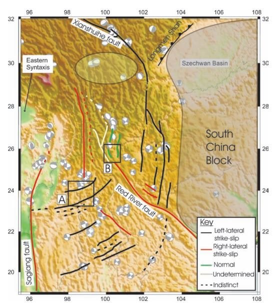
This simplified tectonic map of a ~1,200-km-wide region shows a network of active faults in a continental region of pervasive deformation on the southeast margin of the Tibetan Plateau.
Copley, A. (2008), Geophys. J. Int. 174, 1081
Plot of viscosities of various minerals as a function of temperature and water content. The viscosity of a mineral, which affects the strength of a rock containing that mineral, is much lower when it is wet than when it is dry.
Copley, A., et al. (2024), Precambrian Research 403, 107324
Evolution of Continental Deformation
In the podcast, Copley describes how continental deformation and topography evolved since the Archean. (a) The crust is hydrous, hot and weak, and can support only minor topography. Melting in thicker crust begins to generate a residue of strong blocks. (b) The crust is hot, and weak and also contains localized rigid blocks, which can support significant topography. Large melt fractions in thick crust generate granitic rocks and leave a strong, anhydrous residue. (c) The crust contains extensive rigid blocks produced by high-grade metamorphism and the extraction of melt. There are plentiful, thick mountain belts supported and underthrust by rigid blocks. The rate of production of strong crust by melt extraction slows.
Copley, A., et al. (2024), Precambrian Research 403, 107324
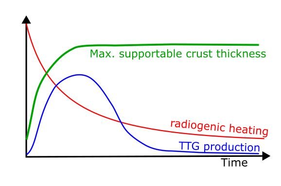
Graph showing the increase of the maximum supportable crust thickness, i.e., topography, over time (green curve). As explained in the podcast, this increase is thought to result from overall cooling of the crust over time as radiogenic heating diminishes (red curve), and from the production of strong blocks that form the anhydrous residue left from partial melting. Evidence for this partial melting appears in the geological record as early granitic-composition rocks, specifically, tonalites, trondhjemites, and granodiorites (TTG. blue curve), which often occur together in geological records, indicating similar petrogenetic processes.
Copley, A., et al. (2024), Precambrian Research 403, 107324
Diffusion of Water Into a Craton
In the podcast, Copley mentioned a study of a region in Canada where rocks containing hydrous minerals were thrust on top of a dry cratonic basement. By dating the events and the rocks involved, Copley and his collaborators were able to determine the rate of diffusion of water into a dry cratonic rock. It was very slow — the water penetrated only 3 km into the basement over a period of about 30 million years. This helps explain the longevity of the cratonic cores of continents. (A) Geological map of the Ungava Peninsula in northern Quebec, Canada. The labeled line shows locations of the cross section in (B). The overthrust “wet” rocks are the rocks of the Cape Smith thrust fold belt and the Narsajuac arc, and the dry basement rocks belong to the Superior craton.
Whyte, A.J., et al. (2021), Geochemistry, Geophysics, Geosystems, 22, e2021GC009988, modified from St-Onge, M. R., et al. (2000), Canadian Mineralogist, 38(2), 379
A vertically exaggerated drawing illustrating processes operating in the ancient thrust belt shown above. Blue arrows indicate areas of water diffusion from the dehydrating overriding wedge into the anhydrous craton below. Thermal diffusion (white arrows) operates along thermal gradients from warmer (lightly shaded) to cooler (dark shaded) portions of the lithosphere. The brittle-ductile transition is shown as a green dashed line.
Whyte, A.J., et al. (2021), Geochemistry, Geophysics, Geosystems, 22, e2021GC009988
Further Reading
Copley, A., et al. (2024), Modern-style continental tectonics since the early Archean, Precambrian Research 403, 107324
Copley, A. (2008), Kinematics and dynamics of the southeastern margin of the Tibetan Plateau, Geophys. J. Int., 174
Whyte, A.J., et al. (2021), Quantifying water diffusivity and metamorphic reaction rates within mountain belts, and their implications for the rheology of cratons, Geochemistry, Geophysics, Geosystems, 22, e2021GC009988
Weller, O. M., et al. (2021), The metamorphic and magmatic record of collisional orogens, Nature Reviews Earth & Environment 2, 781


