

The Magellan spacecraft being released from the Space Shuttle in 1989. All the topographic measurements were made by the altimeter, which is the conical object attached to the side of the dish antenna. It pointed directly downwards and the dish pointed to one side when it was mapping. The dish was used both to capture radar data for imaging the Venusian surface, and also to transmit the data back to Earth. Dan McKenzie used the Doppler fluctuations in this signal to determine the local gravity field.
Image courtesy of NASA

Radar image of Venus from Magellan showing a perspective rendering of the topography data that was correlated with the gravity field data as described in the podcast.
Courtesy of NASA/JPL

Rendering of the topography of Venus and the Earth. The two planets are roughly the same size.
Courtesy of Dan McKenzie

Ultraviolet image of the atmosphere of Venus showing the dense clouds of sulfuric acid droplets.
Taken by Pioneer Venus Orbiter in 1979, courtesy of NASA

Map of the topography of Venus from the Magellan spacecraft.
Courtesy of Dan McKenzie
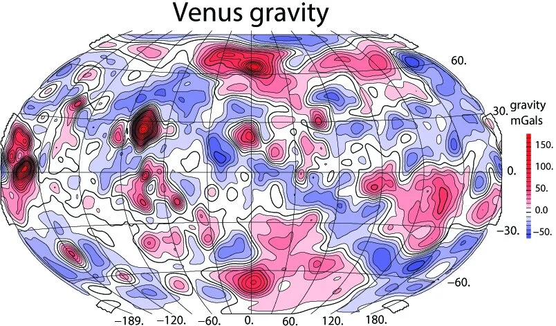
Map of the gravity of Venus inferred from the Doppler measurements of the radio signals from Magellan.
Courtesy of Dan McKenzie

Map of the topography with the effect of convection of the mantle below the elastic plate removed. What remains is the topography that is supported by the plate. Dan McKenzie analyzed this to determine that the thickness of the Venusian elastic plate is 20-30 km.
Courtesy of Dan McKenzie