
Mike Searle on the Mountain Ranges of Central Asia
Listen to the podcast here or wherever you get your podcasts.
Glossary of terms used in the podcast.

The Karakoram, Hindu Kush, and Pamir are among the major Central Asian mountain ranges that contain some of the highest peaks in the world. In the podcast, Mike Searle describes the origin and geology of six Central Asian ranges and how they relate to the Himalaya and the collision of the Indian plate with Asia. India continues to plow into Asia to this day. How is this movement accomodated? Searle explains the extrusion and crustal shortening models that have been proposed and describes the detailed mapping in the field in northern India he and his colleagues conducted that showed that both mechanisms are operating.
Searle is Emeritus Professor of Earth Sciences at the University of Oxford
Podcast Illustrations
Courtesy of Mike Searle unless otherwise indicated.

Satellite image labeled with five of the mountain ranges Searle discusses in the podcast — the Karakoram, the Hindu Kush, the Pamir, the Kunlun Shan, and the Tien Shan. The Gangdese, also discussed, is to the east of the region covered by the image along the southern margin of Tibet.
NASA

Main continental blocks and terranes of Asia and position of the suture zones, several of which are mentioned in the podcast. The mountain ranges that are the topic of the podcast lie between India and the Central Asian Orogenic Belt. BH, Bayan Har; Hel, Helmand; HK, Hindu Kush; Ind. Indochina; Kh, Kohistan; Ku, Kudi; NQi, North Qiangtang; P, Pamir; Qi, Qilian Shan; SG, Songpan–Garzeˆ; Sib., Sibumasu; SQi, South Qiangtang; WB, West Burma.
Suture zones: 1, Indus–Yarlung–Zangbo; 2, Bangong Nujiang; 3, Yushu–Batang; 4, Jinsha; 5, Longmu Co–Shanghu; 6, Panjao; 7, Solonker; 8, Jilin; 9, Mongol–Okhotsk; 10, Kunlun–Anyemaqen.
Jolivet, M. (2015), Geological Society, London, Special Publications, 427, http://doi.org/10.1144/SP427.2
The Karakoram

Many parts of the central Asian mountain ranges are not accessible by road. Therefore, in the 1980s, Searle and his colleagues organized major Himalayan mountaineering expeditions to do geological field work, especially for terrain at higher elevations. The image shows Searle and a porter riding a yak across the North Braldu river in the Karakoram near the Pakistan-China border.

Geological map of northern Pakistan spanning the Karakoram and Hindu Kush. The map shows the main granitic-type rocks that were formed both before and after the India-Asia collision and that occur in the Asian plate, north of the suture zone (SSZ) between the Indian and the Asian plates. The massive Baltoro granite is shown in black.
Hildebrand, P.R. et al. (1998), Geology 26, 871

In the podcast, Searle discusses the Barrovian regional metamorphism that accompanied the India-Asian collision and the metamorphic facies corresponding to the peak temperature and pressure experienced by the rocks. The pressure-temperature (PT) zones corresponding to the various facies are shown in the diagram. In the Karakoram, the lower-grade rocks are greenschist facies, with chlorite, biote, and garnet as the incoming metamorphic minerals with increasing PT. The higher-grade rocks are amphibolite facies with staurolite, kyanite, and sillimanite as the incoming metamorphic minerals.
Courtesy of the Open University

The Trango Towers are granite cliffs that rise about 3,000 meters above the Baltoro glacier in the far northeast of Pakistan. In the podcast, Searle explains that the Baltoro granite, which is what is exposed in the Trango Towers, is a giant, continuous batholith that was emplaced 13-20 million years ago during the intense regional metamorphism accompanying the India-Asia collision.

Landsat image showing the Baltoro glacier, center.
NASA
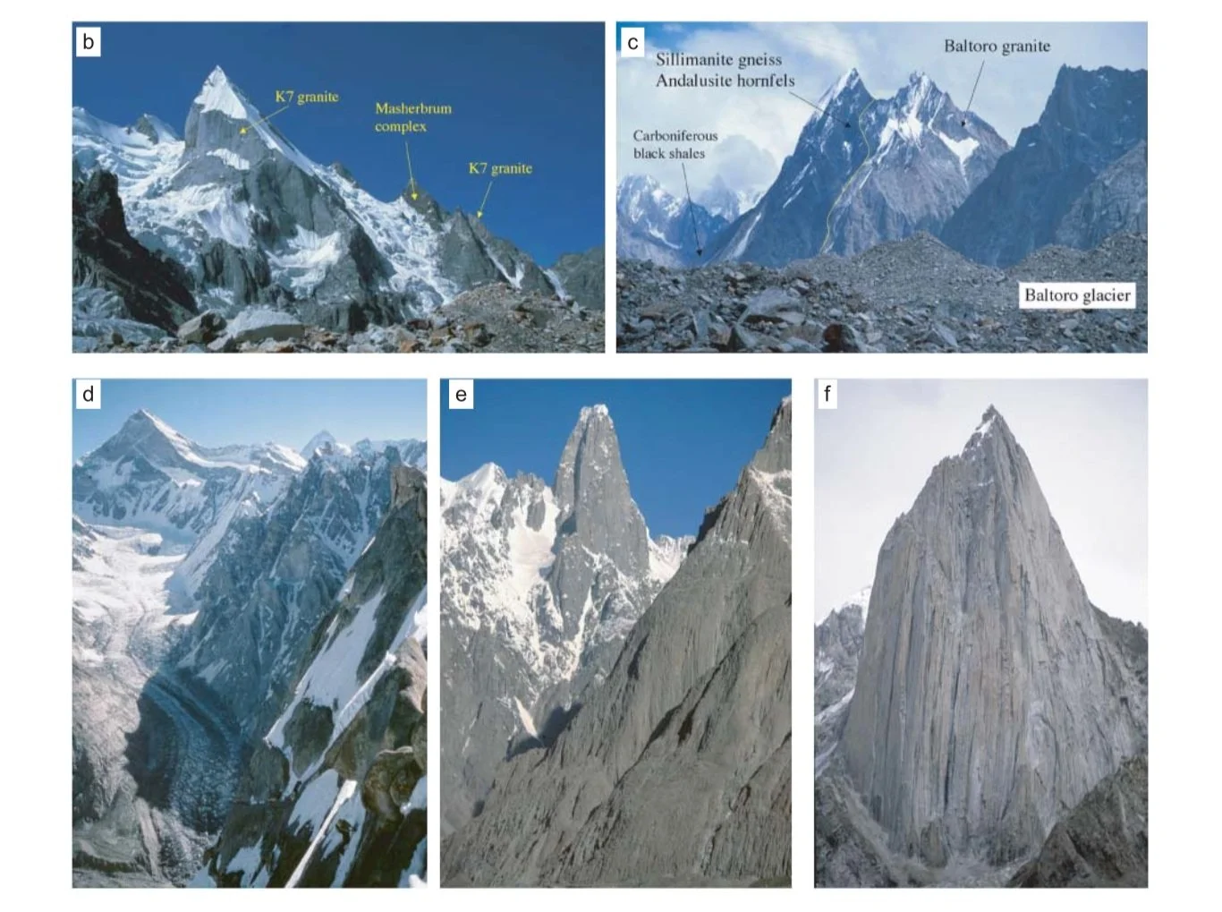
Annotated photographs of mountains that lie within the region imaged by Landsat above. (b) Layla peak, the sharply pointed summit at left, consists of orthogneissses (formed by metamorphosing igneous rocks) with a granite intrusion (K7 granite) dated at 21.7 Ma. (c) Taken from the rock-strewn surface of the Baltoro glacier, the photograph shows the northern margin of the Baltoro batholith. The heat from the intruding Baltoro granite metamorphosed the adjacent Carboniferous black shales to sillimanite, cordierite, and andalusite hornfels. (d) Another image showing the northern margin of the Baltoro batholith, here consisting of the Baltoro granite of the Lobsang Spire (foreground at right with a climber near the bottom for scale). The rest of the image shows the pre-collision orthogneisses of the Cretaceous Muztagh Tower (top left). (e) South face of the Uli Biaho Tower (6,427 m) showing homogeneous granite. (f) Another homogeneous granite tower, here with 1,800-m-high cliffs (Shipton Spire, 5,885 m).
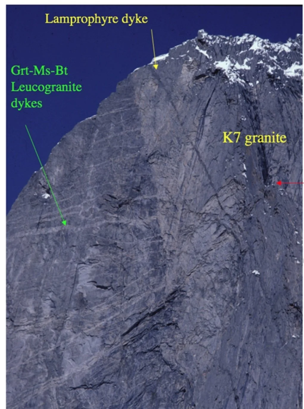
Cliff profile in the Hushe Valley, Pakistan, shows gneisses formed before the India-Asia collision. They are intruded by Baltoro granite (K7 granite), and later cut by a thin lamprophyre dyke. In the podcast, Searle explains that lamprophyre dykes have a geochemical signature that tells us they originate from the mantle. The presence of these dykes suggests that hot material from the mantle may have been the source of the extra heat needed to melt the huge volume of crustal rock that then cooled and formed the giant Baltoro granite batholith.
Hindu Kush

In the podcast, Searle describes the seismic zone in the Hindu Kush where exceptionally deep earthquakes are occurring. The map shows that the deep earthquakes define a narrow region, which reveals where the old, cold slabs of lithosphere are subducting — a deep one from the Hindu Kush dipping toward the north and a shallower one from the Pamir dipping toward the south. The abbreviations label faults, thrust systems, and a suture zone (SSZ).
Peng, C.-C., et al. (2020) Earth Planet. Sci. Lett. 530, 115905

Model of the Hindu Kush seismic zone with an interpretation of possible ultra-high-pressure (UHP) metamorphic rocks formed by subduction of continental rocks to depths of over 200 km. Continental UHP rocks are known from over 20 world-wide occurrences ranging from Cambrian to Pliocene. These rocks include eclogites, some with a high-pressure polymorph of quartz called coesite, and others bearing diamonds. In the podcast, Searle suggests that two converging continental subduction zones, the deep Hindu Kush zone and the shallower Pamir zone, are elevating the Pamir plateau.
Searle, M., et al. (2001), Journal of Geology, 109, 143
Pamir
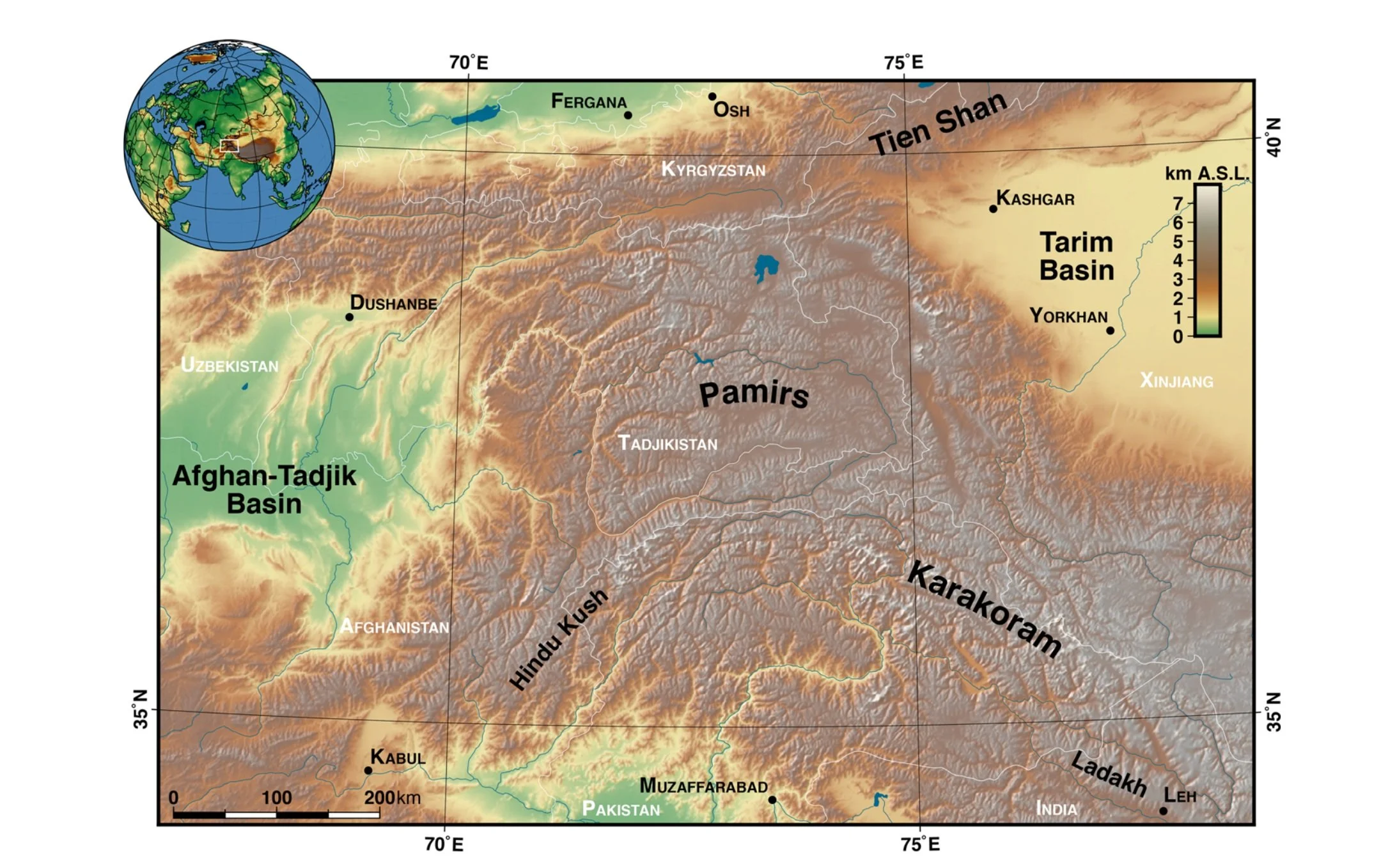
Digital elevation model for the Pamir plateau and adjacent ranges. The Pamir forms an extended region of high elevation running from the Karakoram-Hindu Kush in the south to the Tien Shan in the north.
US Geological Survey

Photograph of the Pamir and Karakoram looking east, taken from the International Space Station.
Photo: Tim Peake and NASA; geological interpretation: Searle, M. P., et al. (2018), Geol. Soc. London Special Publication 483

Simplified geological map of the Pamir-Karakoram-western Tibet region showing the major terranes, suture zones, and faults. The region covered by the map is shown in the inset at top left. The Shyok suture marks the border between the Indian plate and the Asian plate. In the podcast, Searle discusses the two syntaxes at each end of the Himalaya that may affect the continental subduction mode — ultra-deep to the east in the Hindu Kush and shallow to the west along the Karakoram and the Himalaya. The 8,126-m peak Nanga Parbat (NP) is located at the western syntaxis. The map also shows the prominent strike-slip faults — the Karakoram fault and the Altyn Tagh fault — along which the extrusion of Tibetan crust is thought to occur (see below).
Searle, M. P., et al. (2018), Geol. Soc. London Special Publication 483
Tibet and the Accommodation of Northward Movement of India

Conceptual diagram of the underthrusting of lower Indian crust and shortening of the upper Indian crust. (a) Simplified pre-collision disposition of India and Asia separated by the Tethyan Ocean. (b) The model originally proposed by Argand in 1924 with about 1,000 km of underthrusting of Indian crust beneath the Asian crust, resulting in the double-thickness crust of Tibet. (c) The updated Argand-type model described in the podcast in which the upper Indian crust has been scraped off to form the Himalaya, and the Precambrian lower Indian crust has underthrust north under Tibet. In this model, about 500 km of crustal shortening across the Neoproterozoic-Phanerozoic rocks of the Himalaya is balanced by 500 km of northward underthrusting of the still older Archaean-Mesoproterozoic Indian lower crust.
Searle, M. et al. (2011) Journal of the Geological Society 168, 633

In the alternative model as to how India’s northward movement is being accommodated, a rigid block of Tibetan crust is extruded to the east between large strike-slip faults—the Altyn Tagh fault on the northern side and the Karakoram fault on the southern side. Reconstructions of SE Asia according to the extrusion model are shown here: (a) at c. 32 Ma and (b) at 16 Ma. (c) Experiments with plasticene (non-hardening modeling clay) showing deformation by a rigid Indian plate of a layered plasticene block with a free boundary on the eastern side. “Faults” develop and blocks extrude to the east.
(a), (b) Leloup et al. (2001) and Replumaz et al. (2003); (c) Tapponnier et al. (1982) and Peltzer et al. (1988)

Horizontal velocities measured by GPS satellites across Tibet relative to a stable Eurasia, which supports the model of Tibetan crust extruding to the east. In the podcast, Searle explains that detailed mapping across the Karakoram strike-slip fault indicates a maximum of 300 km of slip. So, while extrusion can accommodate some of India’s northward movement, other mechanisms, such as upper-crustal shortening and lower-crustal under-thrusting, must also be playing a role.
Gan et al. (2007)
Further Reading
Searle, M.P. 2013. Colliding Continents. Oxford University Press.
Karakoram:
Searle, M.P. 1991. Geology and Tectonics of the Karakoram Mountains. (With Geological Map of the Central Karakoram). John Wiley & sons, Chichester.
Searle, M.P., Parrish, R.R., Thow, A.V., Noble, S.R., Phillips, R.J. & Waters, D.J. 2010. Anatomy, age and evolution of a collisional mountain belt: the Baltoro granite batholith and Karakoram Metamorphic Complex, Pakistani Karakoram. Journal of the Geological Society, London, 167 183-202 doi: 10.1144/0016-76492009-04
Phillips, R.J. and Searle, M.P. 2007. Macrostructural and microstructural architecture of the Karakoram Fault: Relationship between magmatism and strike-slip faulting. Tectonics, 26, TC3017 doi:10.10292006TC00946
Phillips, R.J., Parrish, R.R. and Searle, M.P. 2004. Age constraints on ductile deformation and long-term slip rates along the Karakoram fault zone, Ladakh. Earth and Planetary Science Letters, 226, 305-319.
Hindu Kush:
Hildebrand, P.R., Searle, M.P., Shakirullah Khan and van Heist, H.J. 2000. Geological Evolution of the Hindu Kush, NW Frontier, Pakistan: active margin to a continent-continent collision. In: Khan, M.A. et al. (Eds) Geological Society, London Special Publication, 170, 277-293.
Hildebrand, P.R., Noble, S.R., Searle, M.P., Waters, D.J. and Parrish, R.R. 2001. Old origin for an active mountain belt: Geology and geochronology of the eastern Hindu Kush, Pakistan. Geological Society of America Bulletin, 113, 625-639.
Searle, M.P., Hacker, B.R. and Bilham, R. 2001. The Hindu Kush seismic zone as a paradigm for the creation of Ultrahigh-pressure diamond and coesite bearing continental rocks. Journal of Geology, 143-153.
Pamir and Tien Shan:
Schwab, M. et al. 2004. Assembly of the Pamirs: age and origin of magmatic bodies from the southern Tien Shan and southern Pamir and relation to Tibet. Tectonics, 23, doi: 10.1029/2003TC001583
Searle, M.P. and Hacker, B.R. 2018. Structural and metamorphic evolution of the Karakoram and Pamir following India-Kohistan-Asia collision. In: Treloar. P. and Searle, M.P. (Eds) Himalayan Tectonics: A modern Synthesis. Geological Society, London Special Publication, 483. https://doi.org/10.1144/SP483.6
Tibet:
Molnar, P. and Tapponnier, P. 1975. Cenozoic tectonics of Asia, effects of a continental collision. Science, 189, 419-426.
Tapponnier, P. and Molnar, P. 1977. Active faulting and tectonics in China. Journal of Geophysical Research, 82, 2905-2930.
Chung, S-L. et al. 2005. Tibetan tectonic evolution inferred from spatial and temporal variations in post-collisional magmatism. Earth Science Reviews, 68. 173-196.
Searle, M.P., Elliott, J.R., Phillips, R.J. and Chung, S-L. 2011. Crustal-lithospheric structure and continental extrusion of Tibet. Journal of the Geological Society, London, 168, 633-672. Doi: 10.1144/0016-76492010-139