
Bob Anderson on How Geology Affects Landscape

Bob Anderson is chair of the Department of Geological Sciences at the University of Colorado Boulder. He is a geomorphologist who has studied many diverse aspects of the landscape, focusing recently on Alpine and Arctic landscapes in which ice plays a prominent role. It was his sense of awe and aesthetic appreciation of patterns in nature that drew him into the field. Here he is in eastern Greenland near the outlet of the Helheim ice stream.
Listen to the podcast here or wherever you listen to podcasts.
Scroll down for illustrations that support the podcast. And add your comments at the bottom of the page.
Note - playing the podcast is not supported on Internet Explorer; please use any other browser, or listen on Spotify, Apple Podcasts, etc.
Podcast Illustrations
Images courtesy of Bob Anderson unless otherwise noted.
The Contrasting West and East Edges of the Sierras in California

The 3,000-foot granite wall of El Capitan in Yosemite National Park, California, characterizes the western edge of the Sierras, which consists of rocks with a very low density of flaws. Climbing routes on El Capitan, which make use of cracks, are widely spaced. This also gives the rock great strength and the ability to sustain tall walls. The valley itself, from which the photo was taken, has been deepened by numerous glaciations.

A glacially polished valley wall in Yosemite National Park. The patterns in the rock indicate that the glacier was sliding away from the viewer, aligned with the flutes.

Close-up of a polished granite surface in Yosemite National Park. The width of the view near the camera is about 2 feet.

Google Earth perspective image looking west at the eastern Sierra front and moraines bounding each valley. The hundred-meter scale of these moraines is in great contrast to the tiny moraines in valleys draining westward on the west edge of the Sierras.
Courtesy of Google
Cosmogenic Radionuclide Dating of Surfaces in the Landscape

High-energy cosmic rays enter the Earth’s atmosphere and collide with atoms in the atmosphere, which produces cosmogenic radionuclides, such as carbon 14 and beryllium 10. Of interest here, however, are the high-energy particles that hit the Earth’s surface and collide with atoms in rock to create the cosmogenic radionuclides beryllium 10 and aluminum 26. Since cosmic rays do not penetrate far below the surface, the abundance of these radionuclides is an indicator of how long a rock has been on the surface and exposed to the incident cosmic rays.

This graph shows that when exposed to cosmic rays, the concentration of beryllium 10 atoms in quartz increases at first, and then flattens out as equilibrium is reached between the beryllium production rate and radiogenic decay rate. The sloping part of the curve is the range of time over which the beryllium 10 concentration varies with time, and therefore the timescale when it can be used to date how long the quartz has been on the surface and exposed to cosmic rays. As the graph shows, this timescale is several million years.
Self-Similar Patterns of Cracks in Nature
This series of images shows naturally occurring cracks having broadly similar shapes but spanning scales from a few centimeters to tens of meters.
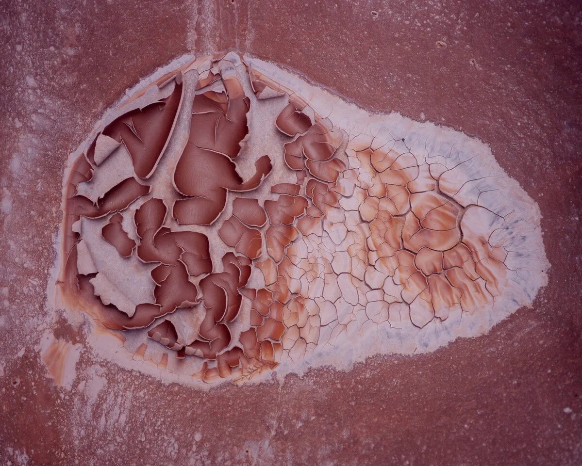
When a material dries out or cools down, it shrinks. As it does so, if the material is homogeneous, it wants to shrink equally in all directions, and cracks form to relieve the resulting stresses. As a crack lengthens, it relieves only the tensile stresses acting perpendicular to the crack. Therefore, a subsequent crack will experience a stress field that is no longer homogeneous, and will tend to form perpendicular to the existing crack so as to relieve the remaining tensile stresses. So the main rule is that cracks join at 90° angles, whether it is paint that shrinks as it dries, or mud that shrinks as it desiccates, or lava that shrinks as it solidifies, or frozen ground in permafrost regions that shrinks as it gets very cold in winter.
In this desiccated mud puddle, the cracks are spaced by about 2 cm.

The cracks in this road sign have a spacing of about 5 cm.

The cracks in paint on caution sign meet at right angles to each other. The bolt head in the center is 1 cm in diameter.

Mud cracks in a desiccated lake bed on Alaska’s North Slope. The caribou and geese tracks indicate that the cracks are spaced by about 30 cm.

Arctic ice wedge polygons with a spacing of about 30 meters.

These frost wedge polygons on Alaska’s North Slope are about 40 meters across.
Edges in the Landscape
Many landforms display sharp corners, or edges, that are maintained as they migrate laterally. These include escarpments, sea cliffs, lumpy outcropped hillslopes, roches moutonées in glacial valleys, and river knickpoints. When the rock being eroded is chopped into discrete blocks, the most vulnerable blocks are those at downstream, downslope or downvalley edges. Removal and transportation of these blocks of rock maintain a sharp edge, and result in their upvalley or upslope migration. Therefore, rather than simply lowering at miniscule rates all the time, many landscapes lower dramatically as a corner migrates past, with little change during the long intervals between such events.

Bob Anderson on an eroding permafrost clifftop at the edge of the Beaufort Sea on the North Slope of Alaska.

The Seven Sisters form an eroding chalk sea cliff edge on the English Channel.
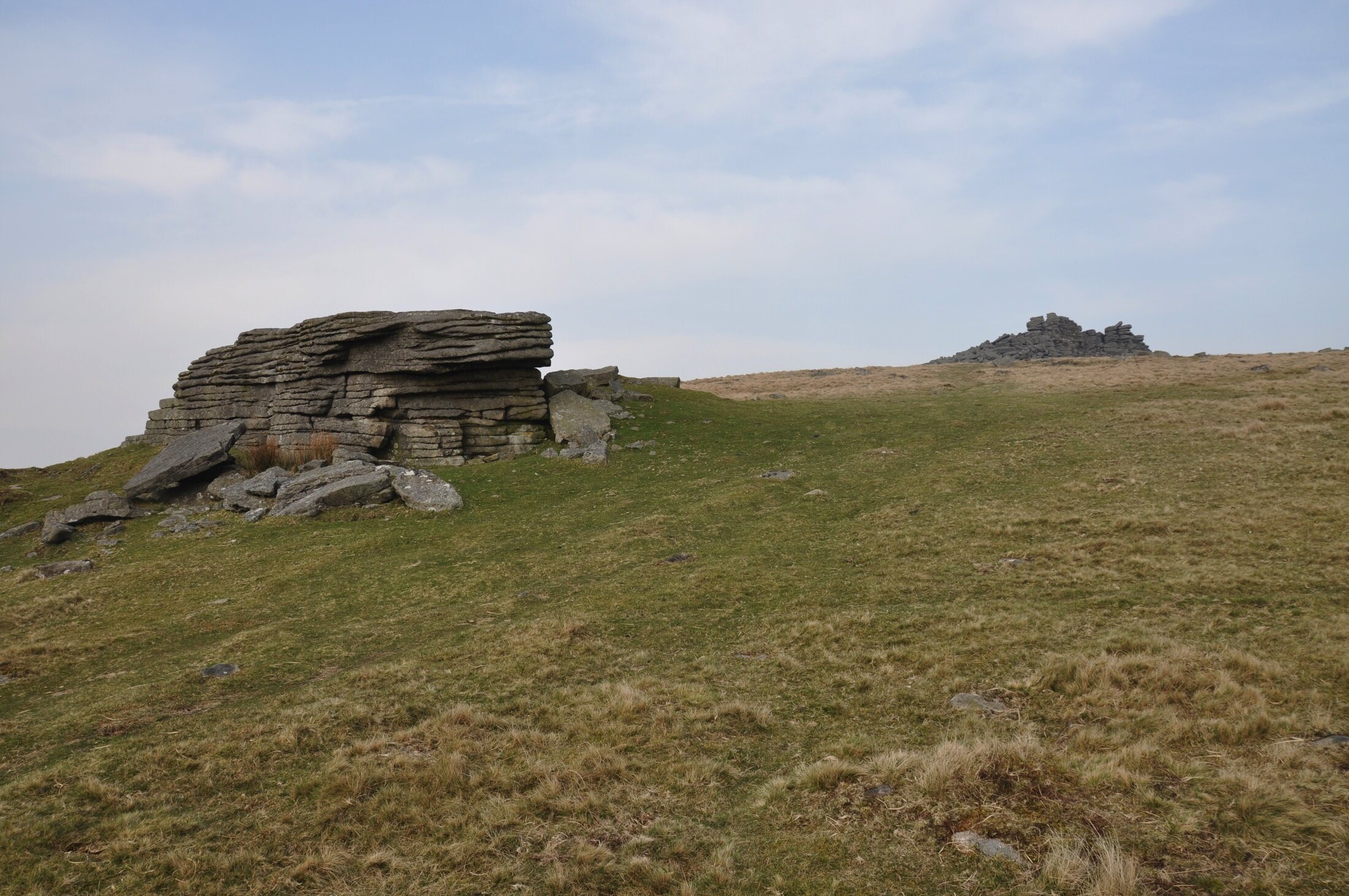
The tors of Dartmoor in Devon, England, form edges on hill slopes. The blocks tumble off the downslope sides of these outcrops.

Sharp steps in the dry channel bed of a river course draining toward the Grand Canyon are an example of knickpoints, which are edges in river channels that move through the landscape.
References
Anderson, R.S., 2014, Evolution of lumpy glacial landscapes, Geology 42(8): 679–682, doi:10.1130/G35537.1 (Published online 9 June 2014).
Barnhart, K.R., R.S. Anderson, I. Overeem, C. Wobus, G.D. Clow and F.E. Urban, 2014, Modeling erosion of ice-rich permafrost bluffs along the Alaskan Beaufort Sea coast, Journal of Geophysical Research - Earth Surface, 119(5): 1155–1179, (Article first published online 28 May 2014), doi:10.1002/2013JF002845.
Glade, R.C., R.S. Anderson and G.E. Tucker, 2017, Block-controlled hillslope form and persistence of topography in rocky landscapes. Geology, 45(4): 311-314. doi: 10.1130/G38665.1.