
Brian Upton on the Unique Rift Zone of South Greenland
Listen to the podcast here, or wherever you get your podcasts.

Brian Upton is Emeritus Professor of Geology at the University of Edinburgh. During his long and prolific research career, he has conducted field studies in many parts of the world, concentrating especially on the Arctic. But throughout his career he has continued to investigate the unique alkaline rocks of South Greenland. As he explains in the podcast, these rocks contain an unrivalled number of exotic minerals, many of them not known to occur anywhere else.
Podcast Illustrations

Simplified Map of Greenland’s Basement Rocks
The crystalline basement rocks of Greenland consist of Precambrian fold belts welded together. The rocks of the Gardar Province, shown in red near the southwestern tip, were intruded into rocks (the Ketilidian fold belt) that were formed about 1,850 to 1,725 million years ago during folding and mountain-building accompanying the assembly of the supercontinent Nuna (also referred to as Columbia).
Courtesy of Thuesen, C.E, GEUS

Reconstruction of the Supercontinent Nuna/Columbia
A reconstruction of the supercontinent Nuna/Columbia at about 1,500 million years ago showing Greenland (orange) in a block together with North America, Baltica, and Siberia. The lines annotated by triangles indicate subduction zones, and the double line indicates a rift zone.
Rogers, J.J.W. et al. (2002), Gondwana Research, V. 5, No. 1, 5

Geological sketch map of the Gardar igneous rocks. The rocks intruded into the Julianehåb granite batholith (pink), which was itself emplaced during the assembly of the supercontinent Nuna/Columbia between 1,855 and 1,795 million years ago. In the podcast, Brian Upton first discusses the giant dykes, which are shown in blue on the island of Tuttutooq to the southwest of Narsaq. The major portion of the podcast is devoted to the one-of-a-kind Ilimaussaq intrusion shown in blue to the northeast of Narsaq. The intrusion is split into two parts by the Tunulliarfik Fjord.
Sorensen et al. eds. (2016), Geological Guide South Greenland, pp. 20-21

Timeline
The age distribution of the Gardar intrusions as determined by radiometric dating. Overall, the activity spanned 170 million years during the Mesoproterozoic. The intrusions discussed in the podcast are highlighted in red. Ivigtut (Ivittut in the map above) was dated at 1,222 million years. It is the site of the cryolite mine. Cryolite, with a formula of Na3AlF6, has an extremely high fluorine concentration and was extensively mined to catalyze the extraction of aluminium from bauxite. OGD and YGD, the older and younger giant dykes, were intruded 1,184 and 1,165 million years ago. The Ilimaussaq complex is 1,160 million years old.
Drawing courtesy of Bartels, A.
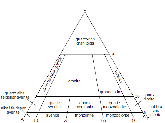
Syenites
The rocks in the intrusive complexes of the Gardar Province are principally composed of syenites that are highly enriched by fractional crystallization and mineral separation in a magma chamber. Igneous rocks that were intruded at depth can be classified according to the proportions of quartz (Q), alkali feldspar (A), or plagioclase feldspar (P) they contain. This classification is commonly mapped onto the ternary QAP diagram shown here. Syenites are plutonic igneous rocks that consist mainly of alkali feldspar without much quartz or plagioclase, and so they occupy the lower left corner of the QAP diagram.
Courtesy of the Open University, © Open University 2010

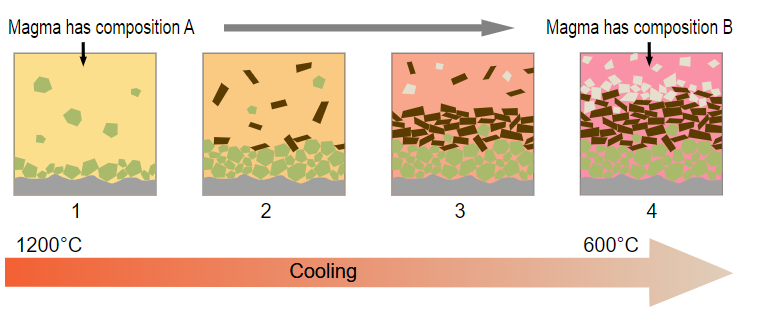
Crystal separation
Schematic representation of crystal settling and floating in a magma chamber. Brian Upton describes this process in the podcast. The high-density minerals that sink are the ones that are rich in magnesium and iron, such as olivine and pyroxene. In the case of the magmas that formed the Ilimaussaq complex, the lighter minerals that floated to the top included sodalite, which has a high sodium content. See diagrammatic cross section of the Ilimaussaq complex below.
Courtesy of Alex Strekeisen after Stephen A. Nelson
Fractional Crystallization
Schematic diagrams showing the principle of fractional crystallization in a magma. As it cools, the magma becomes depleted in the elements that enter the crystals. As Brian Upton explains in the podcast, the magma eventually becomes enriched in the most incompatible elements, so called because they do not readily fit into the crystals that are forming in the melt.
Woudloper, CC BY-SA 3.0
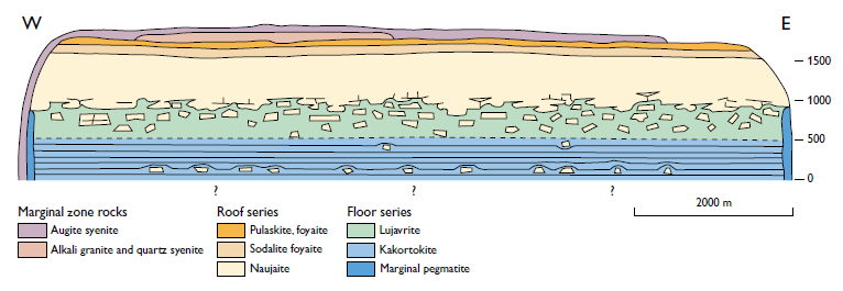
Diagrammatic cross section of the Ilimaussaq complex. Naujaite, shown in beige at the top of the section, is a kind of enriched syenite, often containing the low-density sodium-rich mineral sodalite. Various outcrops of the Ilimaussaq complex show pale blocks of naujaite within the darker lujavrite (also a kind of enriched syenite). The blocks are thought to have foundered off the top layer of the magma chamber that formed the complex.
Andersen, S., et al. (1981), Rapport Gronlands Geologiske Undersogelse 103, 39

Polished slab of Ilimaussaq alkali granite. The green coloration is due to micro-inclusions of aegerine (the sodium endmember of the aegerine-augite series of pyroxenes) within the alkali feldspar crystals. Grey areas are quartz, and the black is mainly arfedsonite, a rare sodium amphibole that is abundant in the Ilimaussaq complex (see photo below).
Courtesy of Brian Upton

Photo micrograph of an extremely enriched rock in the Ilimaussaq complex. The rock is a lujavrite, which is colored green in the diagrammatic cross section of the complex shown above. The image shows albite (colourless), naujakasite (greenish-grey), and the uranium-containing mineral steenstrupine, mentioned in the podcast. Steenstrupine is both a silicate and a phosphate with the formula Na14(Ce,Th,U)6Mn2Fe2Zr(PO4)7Si12O36(OH)2·3H2O).
Upton, B.G.J (2013), Geological Survey of Denmark and Greenland Bulletin 29, p. 88.

Aerial photograph along the Young Giant Dyke looking east-north-east along the island of Tuttutooq. The northern part of the Ilimaussaq complex (with ice) is in the far distance. The valley to the right is excavated by weathering of the dyke’s gabbro.
Upton, B.G.J (2013), Geological Survey of Denmark and Greenland Bulletin 29, p. 22.

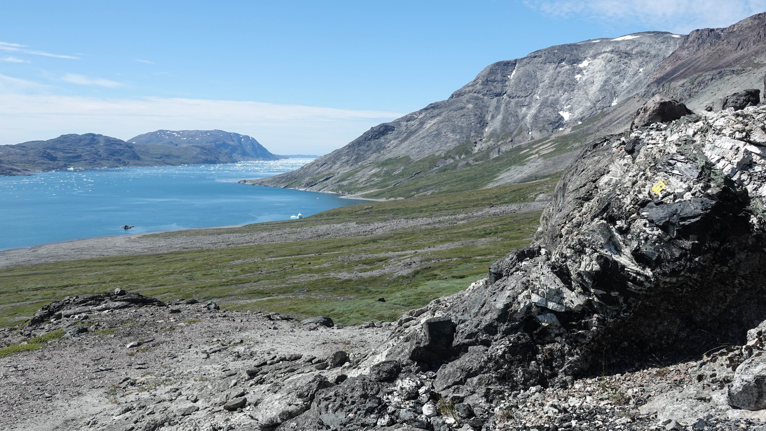
The Ilimaussaq Complex
The Ilimaussaq complex is cut by the Tunulliarfik Fjord. The image shows the northern part of the Ilimaussaq complex. The rocks comprise extremely enriched syenites resulting from high degrees of fractional crystallization from the parental magma. The extremely rare mineralogy results in a surface that is less hospitable to vegetation than the surrounding granite of the Julianhab batholith and the lavas and sandstones of the Eriksfjord formation (see timeline above).
Courtesy of Brian Upton
The Ilimaussaq complex looking west along Tunulliarfik Fjord. In the foreground is a pegmatitic layer containing the largest crystals of the complex. These include white alkali feldspar crystals up to 0.5 meters long, and black crystals of the rare amphibole arfedsonite.
Photo: Oliver Strimpel

Cryolite Mine at Ivigtut
Circa 1941 picture of mining operations at Ivigtut, the site of the world’s only cryolite mine. Cryolite was used as a catalyst and as a source of aluminium. Aluminium was needed in large quantities to manufacture aircraft in the United States during the Second World War. The mine extended far below sea level, but was separated from the sea by only a thin wall of rock.
Courtesy of the Arctic Museum, Bowdoin College
Further Reading
Upton, B. G. J. (2013), Tectono-magmatic Evolution of the Younger Gardar Southern Rift, South Greenland, Geological Survey of Denmark and Greenland (GEUS) Bulletin 29
Sorensen, H., et al., eds. (2016), Geological Guide, South Greenland, GEUS
Henriksen, N. (2005), Geological History of Greenland, GEUS
On the status of mining in Greenland:
https://www.mining-technology.com/analysis/what-is-the-state-of-greenlands-mining-politics/