
Carmie Garzione on Reconstructing Ancient Land Elevation

Carmie Garzione is Dean of the College of Science at the University of Arizona. The past elevation of various points on the Earth’s surface is one of the hardest environmental parameters to reconstruct. But Carmie Garzione has managed to pin down the history of elevation changes by analyzing stable isotopes of carbon and oxygen in carbonate rocks. In the podcast, she describes how the method works, and presents her findings for the Tibetan plateau and the Andes. They show pulses of very rapid (geologically speaking) uplift. She explains what this might be telling us about what has been going on in the lower crust and upper mantle in these regions.
Listen to the podcast here or wherever you listen to podcasts.
Scroll down for illustrations that support the podcast.
Note - playing the podcast is not supported on Internet Explorer; please use any other browser, or listen on Spotify, Apple Podcasts, etc.
Podcast Illustrations
Illustrations courtesy of Carmie Garzione unless otherwise indicated.

One method Carmie Garzione used to determine the elevation at which a sedimentary rock was formed relies on the fractionation of oxygen isotopes. Water vapor containing the heavier oxygen 18 isotope forms stronger H-O bonds and therefore preferentially precipitates out as water. As water vapor in clouds is blown progressively up a slope, it becomes more and more depleted in oxygen 18. When the water is captured in carbonates, either within lake deposits or in paleosols, the ratio of oxygen 18 to oxygen 16 can be used as a proxy for elevation.
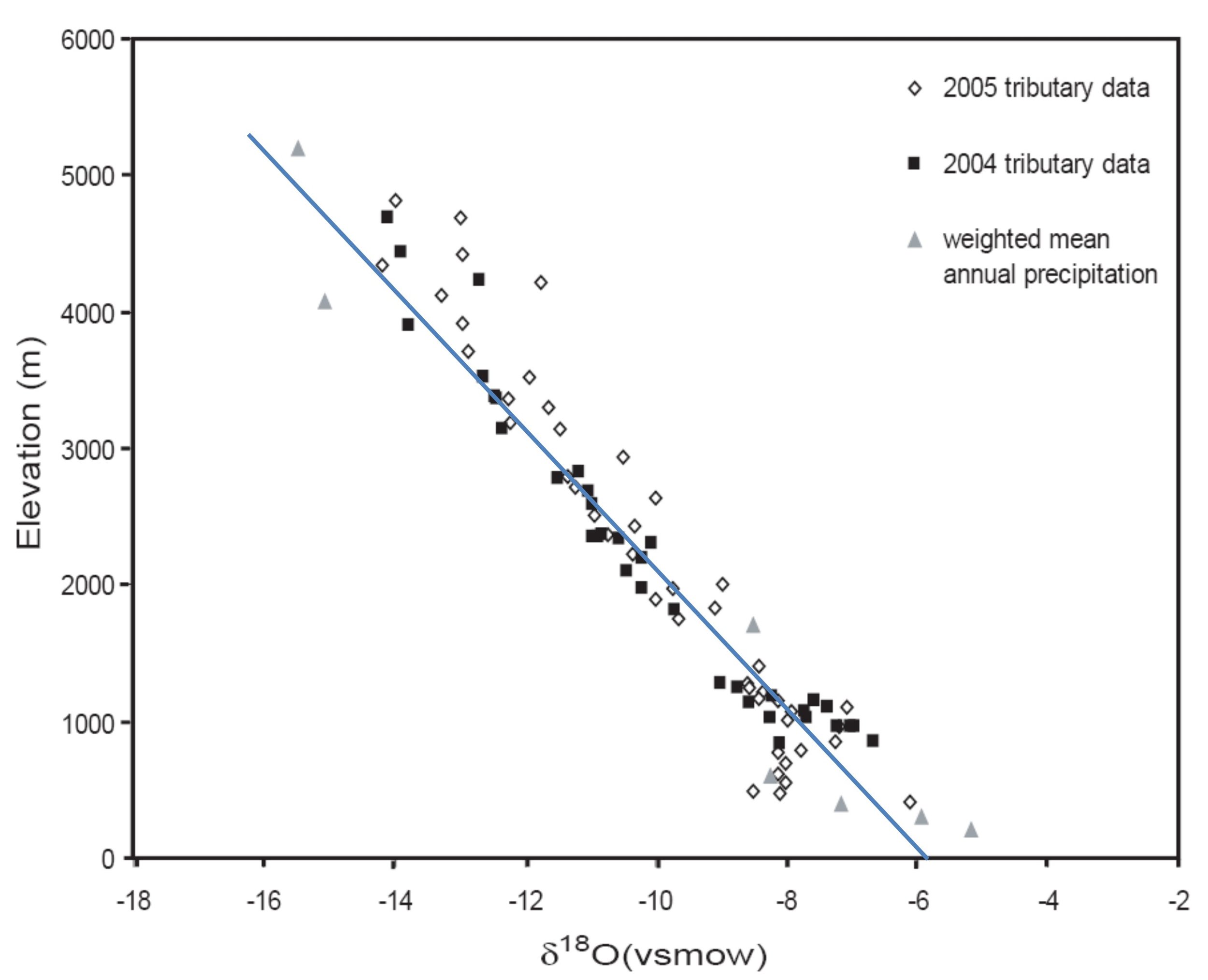
Empirically determined relationship between elevation and the depletion of oxygen 18 in rain water.
Paleoelevation of the Andes

The Western Cordillera is an active volcanic arc that lies above the subducting Nazca plate.

The Altiplano is a sedimentary basin. It was from this basin that many of Carmie Garzione’s carbonate samples were collected. The samples were analyzed using the stable isotope methods described in the podcast to determine the elevation history of the Altiplano.

The Eastern Cordillera lies to the east of the Altiplano and consists of a fold and thrust belt
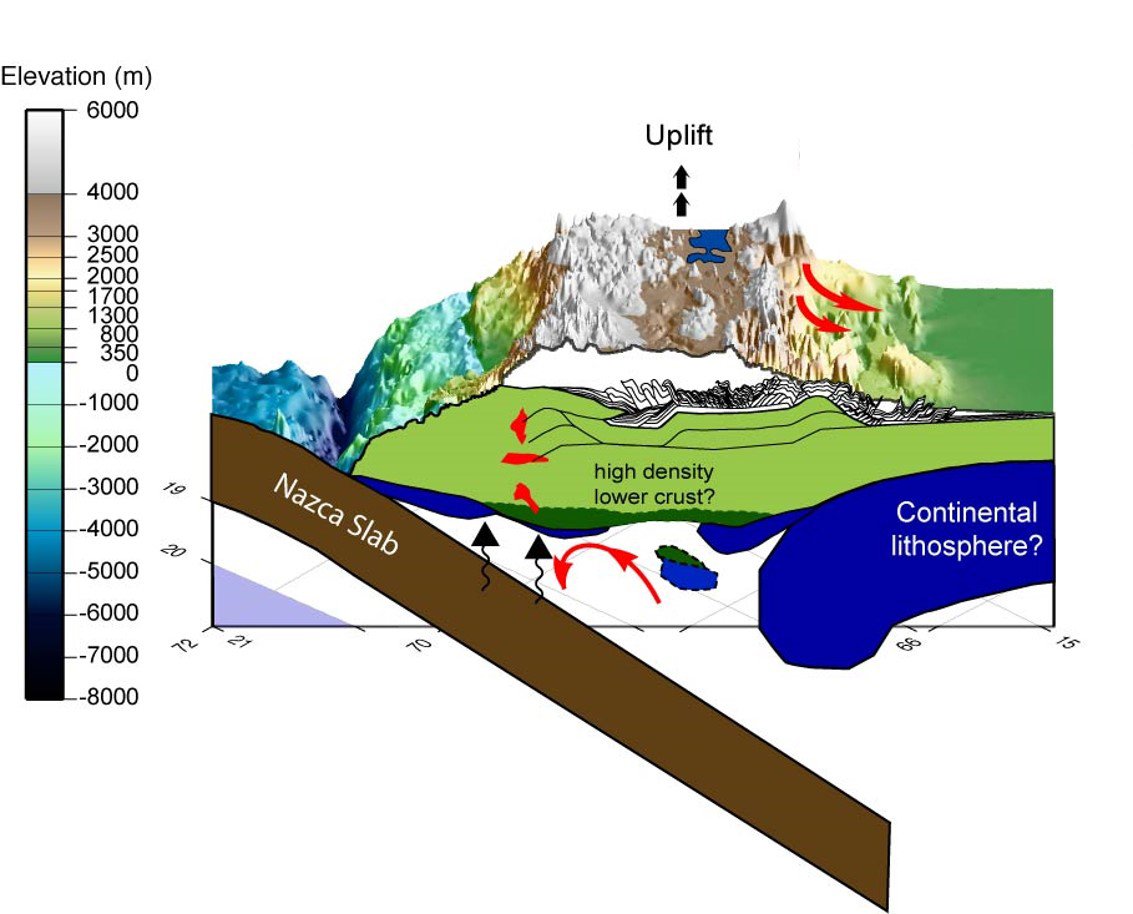
This diagram illustrates the four geodynamic processes that may have played a role in building the Andean plateau. (1) Long-term lateral shortening and vertical thickening of the crust, which causes the surface to “float” higher, i.e., isostatic uplift. (2) Isostatic surface uplift by the addition of magma above the subducting Nazca plate. (3) Surface uplift by removal of dense lower lithosphere, i.e., foundering of lower crust into the mantle. (4) Redistribution of crustal material by mid to lower crustal flow.

The geological setting. The Central Andes overlie a zone where the Nazca plate subducts at a dip angle of 30°. The Altiplano is an internally drained sedimentary basin with low relief topography and an average elevation today of about 4 km. It is flanked by a chain of volcanos on its west called the Western Cordillera, and a fold and thrust belt on its east called the Eastern Cordillera.

The central Altiplano is one of the regions studied by Carmie Garzione to determine its elevation history.

Elevation histories for the central Altiplano region shown above as determined using various methods for determining paleoelevation. The results suggest a period of rapid surface uplift between 10 and 6 million years ago.

The Eastern Cordillera region is another region that was part of the Andes paleoelevation study.

The paleoelevation history of the Eastern Cordillera shows a period of relatively rapid uplift between 24 and 17 million years ago. Blue = oxygen isotope data; yellow = clumped isotope data.

A comparison of the paleoelevation results for the three indicated regions of the Andean Altiplano are compared in the plot below.

The paleoelevation studies suggest that the period of large-magnitude surface uplift of the Altiplano propagates from south to north from middle to late Miocene time (15-5 million years ago). Blue = oxygen isotope fractionation data; pale blue and red = clumped isotope data.

In the podcast, Carmie Garzione describes a possible mechanism that would explain a rapid pulse of surface uplift. As the lithosphere is laterally compressed and shortened as a result of the subduction of the Nazca plate, it thickens. The dense lower lithosphere then heats up to the point where it can detach from the lithosphere and sink into the mantle. The loss of this heavy anchor causes the remaining lithosphere to become more buoyant and rise.