
John Wakabayashi on the Franciscan Complex

The Franciscan Complex contains a great variety of rock types, from metamorphosed seafloor basalts to layers of shales and mudstones. While the metamorphic minerals in certain rocks attest to burial up to a depth of 70 km before emerging on the present-day surface, others appear to have made a smooth passage from a subduction zone trench into the Franciscan Complex.
John Wakabayashi is a Professor in the Department of Earth and Environmental Sciences at California State University, Fresno. He has devoted much of his 40-year research career to the Franciscan Complex.
Podcast Illustrations
Images courtesy of John Wakabayashi unless otherwise noted.

Present-Day Tectonic Context
As its name suggests, the Franciscan Complex is a strip of disrupted rocks along the coast of California stretching about 200 km north and south of San Francisco as indicated by the black rectangle in the image. It testifies to the presence of a former subduction zone. Today, subduction has ceased, with the Pacific plate moving transversely with respect to the North American plate. This motion is accommodated by strike-slip faults, of which the San Andreas Fault is the largest.
Map from USGS

Geological Map of Western California
The map shows the three belts (Coastal, Central, and Eastern) that make up the Franciscan Complex. In general, the Coastal Belt is only weakly deformed, the Central Belt is chaotic, and the Eastern Belt is highly deformed. The metamorphic grade, i.e., the temperatures and pressures to which the rocks have been subjected, increases from the Coastal Belt to the Eastern Belt. The respective metamorphic facies are mainly zeolite, prehnite-pumpellyite (with blueschist blocks), and blueschist (with eclogite blocks). Metamorphic facies are described in the next figure.
Courtesy of the Open University, © Open University 2013

Diagram Illustrating the division of pressure-temperature (P-T) space into metamorphic facies
Each colored field in the P-T space is defined by a distinctive assemblage of minerals that grow in the the rocks when they are subjected to the corresponding P-T conditions. The hatched area shows the low-temperature, high-pressure range of conditions commonly encountered in accretionary prisms and deeper levels of subduction zones. These conditions arise because the subducting slab remains cooler than the surrounding mantle rocks as it subducts and pressures rise.
Courtesy of the Open University, © Open University 2013

Cartoons illustrating successive stages in the development of an accretionary prism. (a) illustrates how stacked-up fault-bounded sections (an imbricate stack) develop at the toe of the prism. (b) shows how sediment may be successively underplated to the bottom of the prism.
Courtesy of the Open University, © Open University 2013
Accretionary Prism Flow Models

Corner flow model. Motion is induced by the drag of the subducting plate on the bottom of the wedge. The model assumes the upper crustal sediments in the wedge are not consolidated.

Channel flow model, in which sediment is off-scraped, underplated, or resubducted within a pattern of return flow. Corner flow and channel flow are each broadly consistent with ranges of computer models having different parameters.
Note, the vertical scale is exaggerated in these diagrams.
Courtesy of the Open University, © Open University 2013

(a) Folded sediments from an accretionary prism on Santa Catalina Island, California. The veins cutting across the fold structure show that there were fluids circulating in the prism. (b) Mélange from Anglesey, Wales, UK, with blocks in a highly deformed, fine-grained matrix. (c) Schematic cross-section of an accretionary prism showing a variety of deformation mechanisms within the prism. Many of these processes could contribute to the formation of mélanges.
Courtesy of the Open University, © Open University 2013

One of the many detailed geological maps of the Franciscan Complex prepared by John Wakabayashi. This one is a projection along the angle of dip of the units of the geology of the Marin Headlands region. It illustrates the imbricate fault repetitions of sandstones, shales, and basalt, as shown in the cartoon diagram above.
Wakabayashi, J. (2017), Progress in Earth and Planetary Science (2017) 4:18

Roadcut at the Marin Headlands north of the Golden Gate Bridge. The red-brown blocks are chert, and the olive-brown rocks are basalt. Multiple faults have placed basalt over chert, but the chert overlies basalt on depositional, i.e., the original contacts. Chert is a hard, fine-grained rock composed of silica. It was deposited onto the basaltic oceanic plate and consists of the petrified remains of microorganism skeletons, especially those of radiolaria.

View of part of the northern Diablo Range, showing the typical geomorphology associated with mélange of the Franciscan Complex. The foreground is underlain by mélange with gentle slopes and isolated outcrops of blocks, including some big ones (two peaks at center right). By contrast, the more distant ridge slopes more steeply as it is probably underlain by more coherent Franciscan rocks.
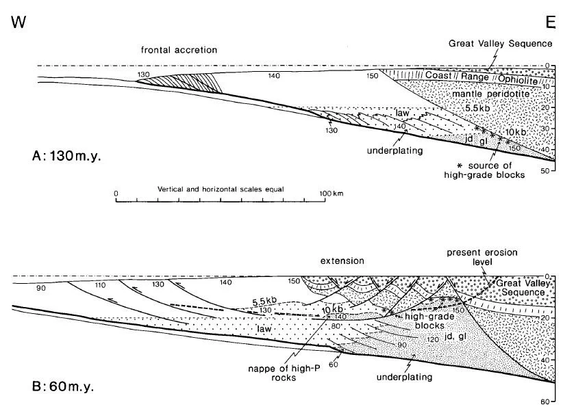
In the podcast, John Wakabayashi mentions the influential 1986 paper by John Platt, which was the first to describe how the rocks of an accretionary prism can be in a state of extension despite being wedged between converging plates. This figure from that paper shows a model of the tectonic evolution of the Franciscan Complex. In the lower diagram (B), he shows how underplating and resultant extension have stretched the prism. The diagram shows approximate ages of sediment in different parts of the complex in millions of years. The pressures at various depths in are given in kilobars (kb) and the depth in km is shown on the scale on the right. The metamorphic grades are indicated by the presence of metamorphic minerals: gl = glaucophane, jd = jadeite, law = lawsonite.
Platt, J.P. (1986), Geological Society of America Bulletin, v. 97, 1037-1053