
Richard Ernst on Large Igneous Provinces
Listen to the podcast here, or wherever you get your podcasts.

Richard Ernst studies the huge volcanic events called Large Igneous Provinces (LIPs) — their structure, distribution, and origin as well as their connection with mineral, metal, and hydrocarbon resources; supercontinent breakup; and mass extinctions. He has also been studying LIP planetary analogues, especially on Venus and Mars. He has written the definitive textbook on the subject.
Ernst is Scientist in Residence in the Department of Earth Sciences, Carleton University, Ottawa, Canada, and Professor in the Faculty of Geology and Geography at Tomsk State University, Tomsk, Russia.
Courtesy of Justin Tang and Carleton University
Podcast Illustrations

Global map showing the distribution of Large Igneous Provinces (LIPs) over the past 500 million years (Ma). Continental LIPs are outlined in black, oceanic LIPs are blue, and silica-rich LIPs are orange. CAMP = Central Atlantic Magmatic Province; HALIP = High Arctic Large Igneous Province; NAIP = North Atlantic Igneous Province.
After Ernst, R. E. et al. (2021), Chapter 1 in AGU Geophysical Monograph 255

Global map showing the distribution of LIPs and silica-rich LIPs during the period 500 - 1000 Ma. As Ernst mentions in the podcast, the Franklin and Thule LIPs, emplaced at 716 Ma, coincide with the onset of the Sturtian glaciation, the first “Snowball Earth” glaciation, and are thought to have played a role in triggering the glaciation.
After Ernst, R. E. et al. (2021), Chapter 1 in AGU Geophysical Monograph 255
Mackenzie Dyke Swarm
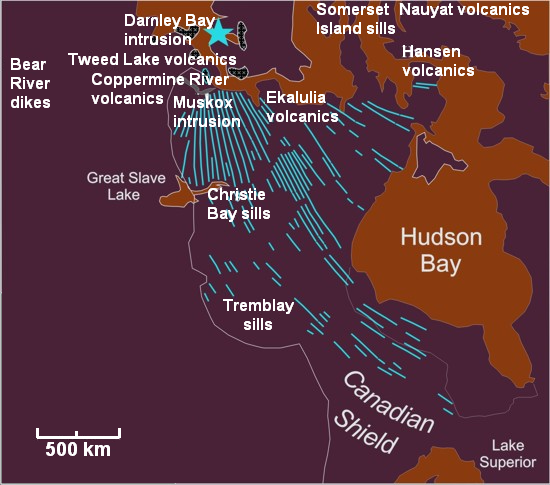
Map of the Mackenzie large igneous province and its sub-features. The blue star marks the approximate focal point for the 1,270-million-year-old magmatic activity.
Credit: Black Tusk

In the podcast, Richard Ernst mentions the deeply eroded Mackenzie event in Canada, the remains of which include the 2,000-km-long Mackenzie dyke swarm and the Coppermine volcanics. The star marks the focal point of the swarm.
Central Atlantic Magmatic Province

Map showing the location of large residual elements of the Central Atlantic Magmatic Province that erupted about 201 million years ago, covering an area of 11 million square kilometers.
Courtesy of Williamborg
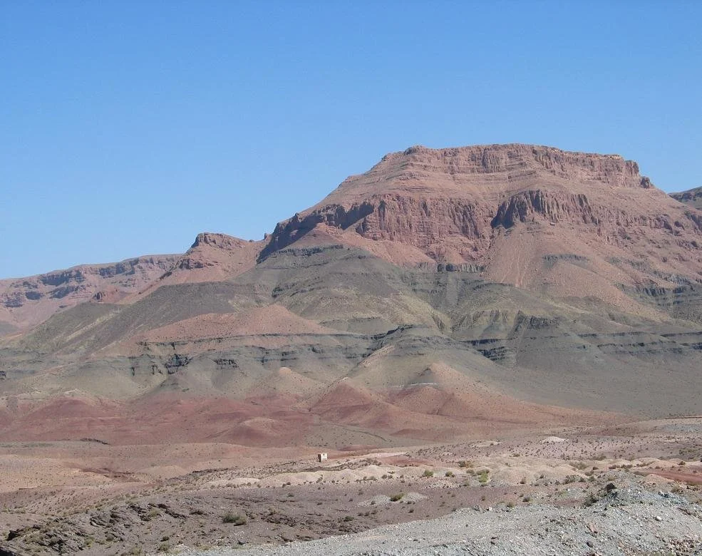
Lava flows of the Central Atlantic Magmatic Province in the High Atlas mountains of Morocco.
Courtesy of Marzoli
Siberian Traps

The Siberian traps form vast ranges of volcanic hills in Siberia between the Ural Mountains and Lake Baikal. They are mainly composed of basalt and tuff from lava and ash expelled 252-251 million years ago at the Permian-Triassic boundary and coincident with Earth’s most severe mass extinction.
Athena Review

A striking example of the multiple successive lava flows of the Siberian Traps in the Putorana Plateau in northern Siberia.

Dyke swarms can be indications of the former presence of a LIP that has been eroded away. Such swarms supplied the large quantities of lava that formed the LIP. In the image, Richard Ernst is collecting samples from a dolerite dyke in the Sahara desert that may have fed a Proterozoic LIP. The dyke forms a ridge of darker material that runs from bottom left to the right peak.

Graph showing the close temporal relationship between the emplacement of large igneous provinces and the onset of the Sturtian “Snowball Earth” glaciation around 720 million years ago. From top to bottom, the graph shows the Hubei–Shaanxi Magmatic Province in South China, the Irkutsk LIP in Siberia, and the Franklin LIP in Laurentia. The insert provides the most precise dates (white stars) on these magmatic provinces.
Lu, K. et al. (2022), Earth and Planetary Science Letters 594, 117736

Cartoon of the formation of a flood basalt. In the podcast, Ernst discusses models of LIP emplacement that invoke the arrival of a plume of hot material originating from the deep mantle. As the plume rises, the head widens, uplifting a wide region of the lithosphere and supplying melt through a swarm of radiating dykes that form along fractures associated with the uplift.
Courtesy of Bob White and Lindsey Smith
Dykes on Venus

In the podcast, Richard Ernst describes the nearly 4,000-km-long Great Dyke of Atla Regio (GDAR) (purple). The image also shows other dykes (orange lines) belonging to the giant radiating swarm of Ozza Mons, Atla Regio plume centre, Venus. Within the region delimited by the blue circle, the dykes radiate out from a posited mantle plume head. Beyond the circle, the dykes change direction in response to the influence of the regional stress field associated with the 10,000-km-long Parga Chasmata (rift system). Owing to the absence of erosion on Venus, long, laterally-emplaced dykes stand out on the surface of Venus as graben.
After El Bilali, H. et al. (2024), Nature Communications, 15:1759
Dikes on Mars

Shaded relief map of the Tharsis volcanic province on Mars from the Mars Orbiter Laser Altimeter. The thin black lines indicate grabens; thin grey lines indicate wrinkle ridges.; thick black lines indicate ridges having an elevation of about 3 km.
Mège, D, et al. (2001), Geological Society of America Special Paper 352
Further Reading
Ernst, R. E. et al. (2021), Large Igneous Province Record Through Time and Implications for Secular Environmental Changes and Geological Time-Scale Boundaries, Chapter 1 in AGU Geophysical Monograph 255
Ernst, R.E. (2014) Large Igneous Provinces, Cambridge University Press, https://doi.org/10.1017/CBO9781139025300