
Roger Bilham on Himalayan Earthquakes
Listen to the podcast here or wherever you listen to podcasts.
Scroll down for illustrations that support the podcast.

Roger Bilham is Emeritus Professor of Geology at the University of Colorado, Boulder. He has conducted a detailed study of the historical record of earthquakes in the Himalaya over the past millennium. He tries to reconcile what we’ve observed with our current understanding of the physical mechanisms at play. This in turn helps us assess future hazard potential. In the podcast, he discusses what we’ve learned about exactly where the earthquakes occur, how they occur, and what determines how much damage they inflict.
Podcast Illustrations
All images courtesy of Roger Bilham unless otherwise indicated.
Historical Earthquake Damage

Damage caused by a 1934 Bihar/Nepal earthquake in Motihari, a few km south of the Nepali border in the Indian state of Bihar. This Magnitude 8.4 earthquake nucleated from a point just south of Mt Everest and ruptured all the way to the Main Frontal Thrust, roughly 30 km north of this location. Shaking for several minutes during the earthquake resulted in liquefaction of sediments in the Ganges Plains and the collapse of the banks of rivers and lakes.

The blocks in the doorway of the Bajaura temple in Raujare in the western Himalaya were displaced laterally during prolonged slow shaking accompanying a violent earthquake, possibly in the 15th century. In 1905, it survived the magnitude 7.8 Kangra earthquake with relatively minor further damage. Some have argued that the survival of medieval temples, such as this one, implies that extreme shaking can never have occurred in parts of the Himalaya. However, although stone structures are generally vulnerable to shaking collapse, some resist the long-period shaking by absorbing the shaking energy within the stone work (hence the displaced blocks in the photo), and only those fittest to survive remain for us to see.
The 2015 Gorkha Earthquake In Nepal

Damage caused by the 2015 Gorkha earthquake in Nepal. This scale of destruction was typical for villages in the impacted area. The structures consist of field stones, often rounded river blocks, that are assembled to form the outer and inner faces of the wall of a village building. Wooden beams support a corrugated iron roof. The stones are bonded with wet clay that has poor cohesion with the stonework and crumbles during an earthquake. The walls collapse in the direction of arrival of the displacement pulse of the earthquake, or are reduced to a pile of rubble after a few minutes of shaking, bringing the roof with them.
Earthquake-resistant buildings are often beyond the reach of villagers. Simple remedies to strengthen field-stone structures take the form of adding wire mesh (chicken wire) to the outside and inside wall linked through the wall by wire or plastic straps. Small amounts of concrete and steel in the form of embedded or capping ring beams can be added by those with the incentive and funding to do so. Programs to undertake such retrofits face an overwhelming inventory of building stock so that it will take many lifetimes to effectively reduce earthquake risk in Nepali villages.
Video of Dabali Square in Kathmandu during the 2015 Gorkha earthquake shows people responding to the southwards lurch of the ground, and then to the subsequent resonance of the sediments that take a further few minutes to abate. Also shown is the position of the ground in map view as recorded by a nearby GPS receiver.
Initially nothing happens. The p wave traveling from the epicenter at 8 km/s arrives first and agitates a couple of birds that fly off. Shortly afterwards, the Himalayan basin on which Kathmandu lies begins to be translated SW and then south at a velocity exceeding 1 cm per second. This displacement is a direct measure of the Himalayan carapace moving southward over the Indian plate along the Main Himalayan Thrust, which here lies about 3 km below the city.
People respond by attempting to maintain their balance.
The sediments in the Kathmandu basin then slosh around in a rotary motion, eventually coming to rest about 1 m SSW of their starting point and about 1 m higher than they were before the earthquake. The 2015 earthquake effectively transferred both elastic and gravitational potential energy to the rocks underlying Kathmandu.
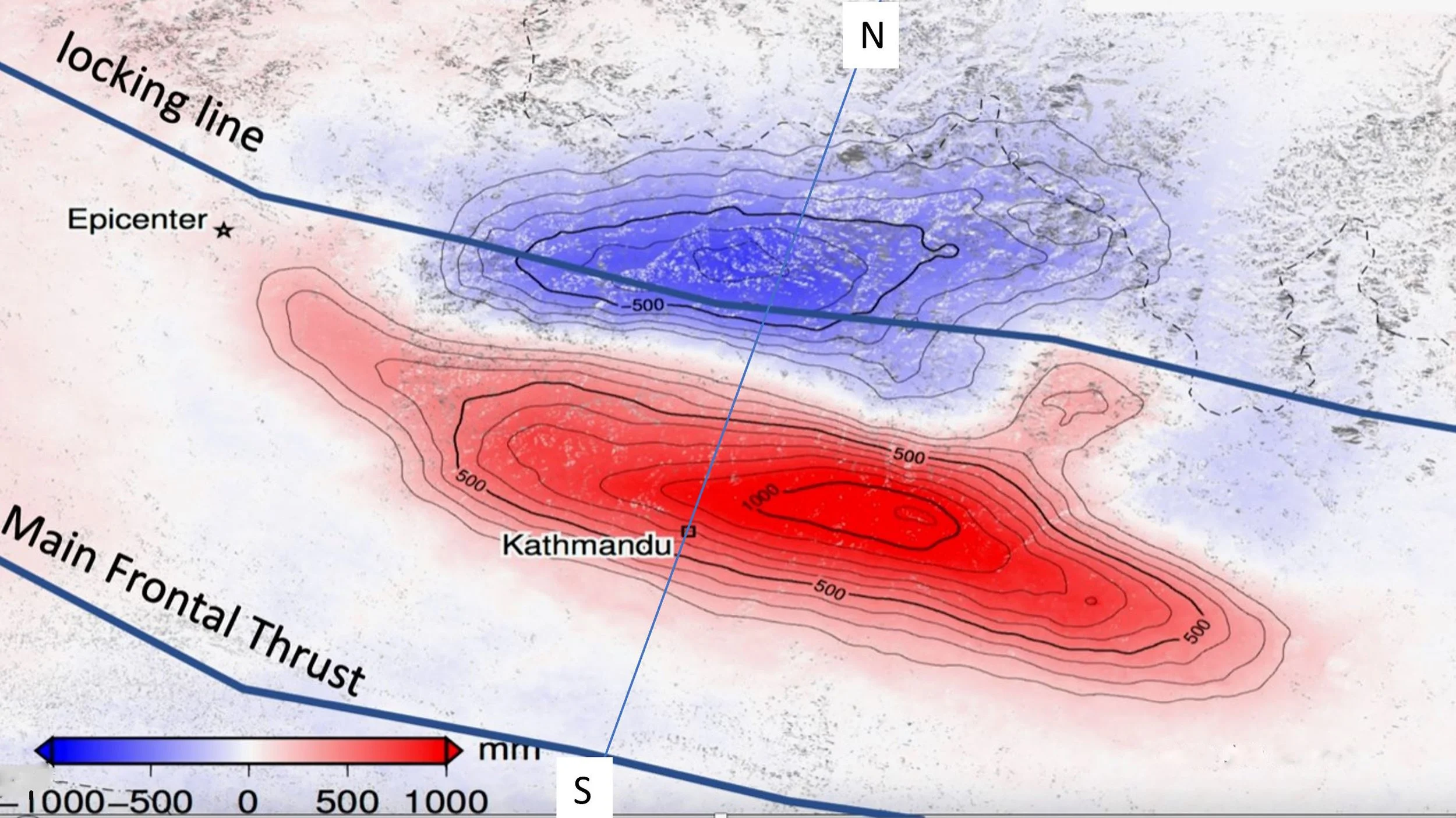
This image shows the depression (blue) of the mountains along the locking line and the uplift of the mountains near Kathmandu (red) over a 2-week period spanning the 2015 Gorkha earthquake in Nepal. The image is an interferogram created by comparing synthetic aperture radar captured during two passes of the ALOS-2 satellite over the region — one before the earthquake and one after. The depicted changes were imposed in less than one minute during the earthquake.
Lindsay E.O.R. et al. (2015), Geophysical Research Letters, 42

Excavated trench across the scarp of the Main Frontal Thrust at the foot of the Indian Himalaya. The earthquake thrust a wedge of dark organic soil containing charcoal 10 m southwards (towards the right) over a lighter-colored thin layer of soil. Carbon 14 dating of the charcoal enables us to date the earthquake to the 13th-15th century. The figure on the ladder searching for charcoal fragments is Steve Wesnousky, who pioneered excavations of the Main Frontal Thrust starting in the 1990s.
Courtesy of Steve Wesnousky

The map shows the locations of recorded Himalayan earthquakes over the past 500 years. Each black blob represents an estimate of the rupture area of the earthquake, i.e., the area of the Himalayan carapace that abruptly moved southwards during the earthquake.
Rupture starts somewhere along the northern edge of these rupture zones, and moves sideways and southwards. The largest of the ruptures extend all the way to the Main Frontal Thrust at the southern edge of the Himalaya, where they lift the Himalaya above the Ganges Plain in the form of an abrupt scarp (shown in the previous figure).
A half dozen of the earthquakes shown, however, failed to rupture all the way to the Main Frontal Thrust. We now realize that these "failed" earthquakes (failed in the sense that they incompletely permit the northward movement of India beneath the Himalaya) deposited huge pools of invisible strain energy at their southern edges. These reservoirs of energy remain dormant until released by great future earthquakes.
Understanding How Large Earthquakes Can Be Generated


The width of the zone of incomplete seismic coupling between the locked portion of the fault to the south and the creeping portion of the fault to the north determines how much movement can occur along the fault when an earthquake is triggered. Assuming the incompletely coupled zone can store a strain of up to one in 10,000 before rupturing, the amount of available displacement during an earthquake for a 10-km-wide zone is 1 m. Such displacements generate earthquakes of magnitude 7.5 or lower.

Megaquakes are generated by displacements of about 10 m. For a maximum strain of one in 10,000, such earthquakes are possible only when the zone of incomplete seismic coupling is 100 km wide.
Cross section along a line shown in the interferogram image above. The earthquake dynamically transported the strain stored at the northern end of the zone of incomplete seismic coupling (purple bubble) southwards along the fault plane to the region around Kathmandu (beige bubble). MFT = Main Frontal Thrust. MDT = Main Dun Thrust. Mw = moment magnitude of an earthquake, commonly referred to simply as magnitude. The scale was devised to extend the Richter scale to magnitudes great than 8, which tend to become increasingly underestimated when using computations based on Richter's original definition of the scale.

Concept diagram showing how elastic energy built up over time at the edge of a creeping zone of the fault can be translated rapidly along the fault during an earthquake. The earthquake simply moves the reservoir of elastic energy from one location to another. The energy may be released eventually when an earthquake ruptures a fault all the way to the surface.
In the top figure, the strain near the lower right edge has approached the failure strain in the rock.
Suddenly, a small part of the Main Himalayan Thrust slips. If it slips too little, it may simply stop in the form of a magnitude 4 earthquake. If sufficient slip occurs, it causes an instability - flash heating, melting or dynamic separation of the lower and upper surface of the fault have been proposed.
The sudden lowering of friction releases more elastic energy, and a ripple rapidly propagates southwards, at velocities of greater than 2 km/second. The rocks above are translated southward.
The ripple continues southwards, either fizzling out through the absence of sufficient elastic energy, or, if sufficient energy is available, making it all the way to the Main Frontal Thrust of the Himalaya, where it offsets the surface fault in the form of a scarp.

Computer modeling of the transfer of elastic energy during an earthquake. The diagrams show a simple boundary element elastic model of the Himalaya before (top) and after (bottom) rupture.
The Tibetan Plateau acts as a backstop, preventing the northward movement of the Himalaya, which, in the top model, are clamped to the Indian plate. The forces of collision cause the rocks in the 20 km layer above the transition zone to be squeezed and rise in the vertical dimension. Using realistic physical parameters for the rocks, the model emulates the observed 5 mm/year of uplift that occurs between earthquakes due to the 15-18 mm/year of horizontal compression.

By setting the friction on the thrust fault beneath the Himalaya to zero, all the compressional strain to the north can be released in the form of slip of the Himalaya southwards. In the example, slip is terminated a few tens of km north of the frontal fault and appears as a bulge.
The prominent regions of strain change in the Indian plate (red for extension and blue for compression) are ignored in interpretations of surface earthquake mechanics. The predictions for the strain changes at depth are correct only for a purely homogeneous elastic model, which we know is a poor representation of the rheology of the Indian plate at depths greater than 20 km.