
Sue Smrekar on the VERITAS Mission to Venus

Sue Smrekar is Principal Investigator of the VERITAS mission to Venus. She has played leading roles in previous planetary exploration missions, including the Mars InSight Lander and the Mars Reconnaissance Orbiter. VERITAS is the first mapping mission to Venus since Magellan in the 1990s. In the podcast, she describes the instruments that will produce maps having orders of magnitude better resolution than previous maps. She explains how the Venusian surface features and interior properties VERITAS should discern will address the following first-order questions: (1) What processes shape rocky planet evolution; for example, are there mantle plumes or subduction zones; (2) What geological processes are currently active; for example, is there ongoing volcanism that is resurfacing the planet today; (3) Is there evidence of past and present interior water either in surface features or within the rocks.
Listen to the podcast here or wherever you listen to podcasts.
Scroll down for illustrations that support the podcast.
Note - playing the podcast is not supported on Internet Explorer; please use any other browser, or listen on Spotify, Apple Podcasts, etc.
Podcast Illustrations
All Images courtesy of NASA/Jet Propulsion Laboratory (JPL) unless otherwise indicated.

VERITAS Mission Overview. In addition to the mapping performed by the VEM and VISAR instruments, the Science Phase II will include a gravity experiment in which the orbit of the spacecraft is tracked to high precision. Perturbations in the orbit are used to measure the local gravity field, which in turn provides information about the interior structure of the planet.
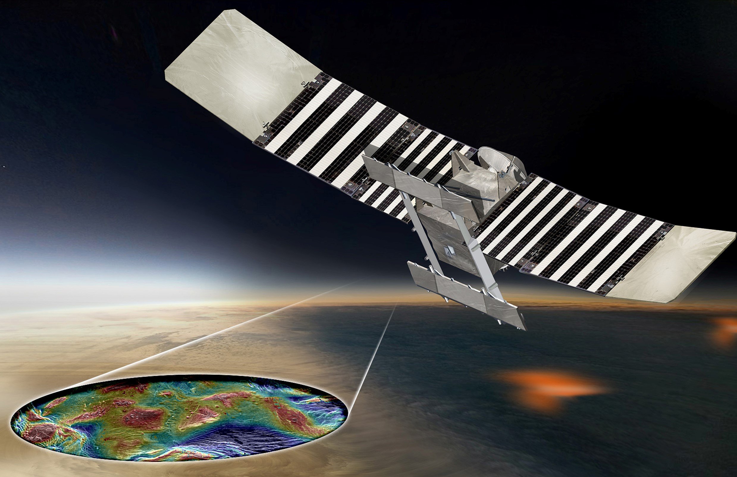
Artist’s rendering of the VERITAS spacecraft and the integrated topographic and surface rock type maps it will produce. The spacecraft is being built by Lockheed Martin.

The VERITAS payload includes two instruments and a gravity experiment. VISAR will produce a digital elevation map having two orders of magnitude better resolution than the Magellan maps. By making repeated measurements of the surface, VISAR will also reveal whether the surface is currently deforming. VISAR is being built by JPL and the Italian Space Agency. VEM is a passive detector in the near infrared with wave bands selected to minimize the confounding effects of the dense Venusian atmosphere. VEM is contributed by the German Space Agency. The gravity experiment will determine the gravity field around Venus to an accuracy of 3 milligals with a resolution of 155 km. For comparison, the gravity at the Earth’s surface is 976 to 983 gals. The telecommunications system on which the gravity experiment relies is contributed by the Italian and French space agencies.

The 14 wavebands of the VEM fall into four categories. The radiation of the surface bands originates from the surface and is selected to reveal rock type as well as the thermal signature of active volcanism. The radiation in the water vapor bands originates in a layer close to the surface and is sensitive to the abundance of water vapor. Volcanic outgassing could cause short-term variability in the water vapor. In the cloud bands, radiation originates at an atmospheric layer above the surface but below the clouds. Because the signal in the cloud bands has no surface or water vapor contributions, the measurements in these bands can be used to remove cloud-induced variability from the other bands. Finally, the background bands (not shown) are sensitive to spectral regions in which the atmosphere is opaque, thus allowing the background signal to be removed from the other bands. The scattering of the outgoing radiation by the high density of clouds places a 50-100 km limit on the resolution of the VEM maps.

These graphs show the emissivity of basalt and of felsic rocks such as rhyolites and granites at the wavebands of the VEM. The shaded red and blue regions show the range of emissivity variation seen in lab samples, while the instrumental uncertainties are shown by the purple bands in the middle of the diagram. The figure shows that the VEM will easily be able to distinguish the rock types on the surface of Venus.

Radar map of the Venusian surface from the Magellan mission. The resolution is 25 km.

Simulated radar imager of Southern California and the San Andreas fault at the 250 m resolution of VERITAS (left) and the 25 km resolution of Magellan (right). The San Andreas fault would not be visible in Magellan imagery.

Topographic map of the island of Hawaii at the 25 m resolution expected from VERITAS. The island is about 115 km across.

Artist’s impression of a subduction zone induced by a plume beneath the erupting volcano. The maps produced by VERITAS will have sufficient resolution to detect structures such as subduction zone trenches, faults, and fracture zones.