
Tony Watts on Seamounts and the Strength of the Lithosphere
Scroll down for podcast illustrations.

Tony Watts is Professor of Marine Geology and Geophysics at the University of Oxford, and a Fellow of the Royal Society. His research focuses on measuring and modeling the structure of the lithosphere, and the deformation it undergoes in response to stresses. Some of the clearest such deformations occur in the seafloor, and he has concentrated on these, both at plate margins, such as trenches, and at plate interiors, especially at seamounts.
Podcast Illustrations
All images courtesy of Tony Watts unless otherwise indicated.
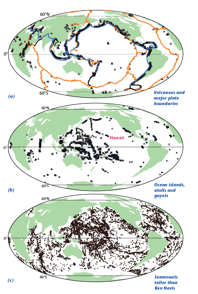
Global distribution of volcanoes, ocean islands, and seamounts. (a) Volcanoes less than ~ 12,000 years old, together with major plate boundaries (blue, subduction zones; orange, mid-ocean ridges; black, transform/strike-slip faults). (b) Ocean islands (solid circles), atolls (x), and guyots (open circles). (c) Seamounts with height above surrounding sea floor greater than height above sea level of Ben Nevis, the mountain with the highest prominence in the UK (1,344 m).

Simple model for the growth of a seamount on the sea floor by eruptions at the summit. The ages are estimates based on consideration of eruption rates and the timescales of stress relaxation in the oceanic lithosphere. The vertical and horizontal growth of the seamount is accompanied by down-sagging of the central part of the edifice, large-scale slope failures, and thrusting and seismicity along a décollement plane.

Bathymetry, topography, and gravity anomaly around the Hawaiian Islands. White lines show the modeled flexure (contour interval is 1 km) assuming that the Hawaiian Islands act as a load on the Pacific plate with an effective elastic thickness (Te) of 30 km. (a) Bathymetry and topography based on satellite altimetry and shipboard soundings. (b) Free-air gravity anomaly.
Sandwell et al. (1997), https://topex.ucsd.edu/marine_topo/ V19.1
Sandwell et al.. (2014), https://topex.ucsd.edu/marine_grav/mar_grav.html V29.1

There is a positive gravity anomaly above a seamount that is at least partially supported by the elastic strength of the lithosphere. If the lithosphere provided no support, the seamount would effectively be floating like an iceberg, and there would be no anomaly. The illustration shows a model for the gravity anomaly and flexure of the lithosphere at a seamount or oceanic island.

Swath bathymetry reveals debris being carried down the slopes of Hawaiian Islands. As Tony Watts explains in the podcast, such debris obscures the surface of the seafloor crust, so one has to resort to seismic methods to determine its shape. (a) Southeast flank of Hawaii showing Loihi, the newest submarine volcano added to the island chain. (b) North flank of Maui, Molokai, and Oahu showing incised canyons, large-scale slope failures and debris-flow deposits with large blocks that overfill the ‘moat’ flanking the islands. Vertical exaggeration ×4. Scales are approximate.

Comparison of observed and calculated flexure to the northeast of Oahu and Molokai in the Hawaiian Islands. The observed data (black dots) are based on seismic reflection profiles. The calculated profiles (red) are based on an elastic plate model with surface topographic loading and modeled plate elastic thicknesses of 10, 25, and 50 km. An elastic thickness of 25 km provides the best fit.

Perspective view (from the northwest) of the seafloor to the west of the island of Hawaii showing the ‘staircase’ pattern of marine terraces offshore of the flank of Mauna Kea, the largest dormant volcano on the island. Secular rises and falls in sea level would not produce such a pattern of former beach levels. Instead, the pattern indicates subsidence of the island as the lithosphere sagged in response to the load of the growing volcano.